


PROPERTY SEARCH

Unsettled weather set to continue across Spain this week: Forecast March 9-12
Expect several more days of rain, snow and rough seas before conditions begin to calm by Thursday

Spain is set for several more days of unstable weather as an Atlantic trough and the passage of a weather front evolve into another spring DANA storm. According to forecasts from the State Meteorological Agency (Aemet), this weather system is expected to influence conditions across much of the country until around Wednesday, before a calmer phase arrives later in the week.
Monday March 9
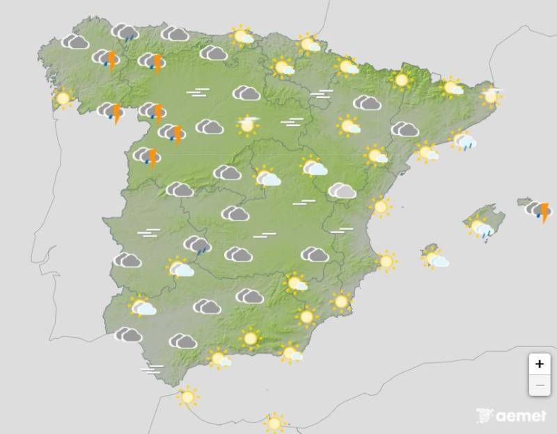
Monday begins with widespread unsettled conditions across much of the country. Seven autonomous communities are under yellow weather alerts for snow, rain or rough seas. Snow warnings are in place in the regions of Asturias, Castilla y León and the Community of Madrid, where snowfall could accumulate between 5 and 10 centimetres within 24 hours in several provinces.
Rain alerts are active in the Balearic Islands, particularly on Mallorca and Menorca, as well as in parts of Catalonia, including Girona where rainfall could reach up to 20 millilitres in an hour. Storms in these areas could bring locally heavy downpours, thunderstorms and occasional hail.
Meanwhile, coastal areas of Galicia and several islands in the Canary Islands face warnings for rough seas. Rain will generally be lighter and more occasional along the southeastern Mediterranean coast.
Tuesday March 10
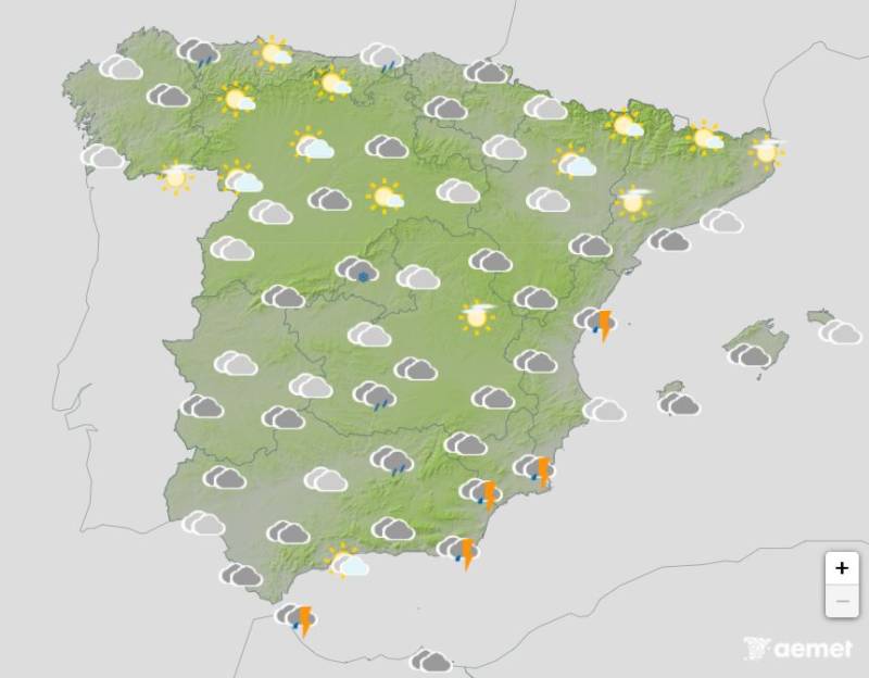
From Tuesday onwards, the probability of rainfall will remain high across large parts of the country, particularly in the central, eastern and southern areas of mainland Spain. During the early hours of Tuesday morning, a bank of rainclouds moving from west to east across Spain is expected to slow and stall over the centre of the country, bringing further rainfall to Madrid and surrounding areas through the morning.
These showers could affect wide areas of the country, with the heaviest rainfall expected in parts of Andalucía, Castilla-La Mancha, Aragón, La Rioja, Navarra and the Basque Country. In inland regions, the precipitation will coincide with the arrival of colder air.
Over the course of the week, maximum temperatures are expected to fall in the northwest and across parts of the Canary Islands, with a particularly noticeable drop inland in Galicia and western Cantabria. By contrast, temperatures along the Mediterranean coast are forecast to rise slightly, while remaining fairly stable elsewhere. Minimum temperatures will generally fall slightly, with light frosts possible on the highest mountain peaks and nearby areas.
Winds will mainly blow from the west and south, generally light but stronger winds are expected along many coastal areas, especially along the northern and southern coasts of the peninsula. In Galicia, winds will turn more northerly with strong gusts, while the Canary Islands will see trade winds with strong gusts in exposed areas.
Wednesday March 11
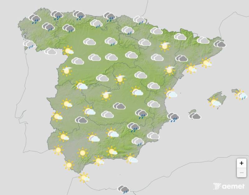
By Wednesday, the DANA is expected to shift towards the Mediterranean side of the country, where the most intense rainfall will particularly affect the Valencian Community. At the same time, a new storm front approaching from the northwest may bring lighter rainfall to other parts of the mainland.
Forecasters stress, however, that the outlook remains uncertain and several different scenarios are still possible as the stormy weather system develops.
Thursday March 12
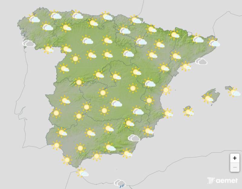
Once we reach Thursday, three days after the start of the DANA storm, meteorologists agree that conditions are expected to begin to become a bit calmer, but that calm will be short-lived. It will be brighter and sunnier, with temperatures ever so slightly back up again, but in reality Thursday will be like being in the eye of a storm.
That’s because the day is likely to act as a transition between the departing storm system and the possible arrival of another Atlantic trough, bringing a temporary pause in the unsettled weather that has affected much of Spain.
For more weather news go to our Weather & Climate page or follow the Spain Weather Watch Facebook group for regular updates
Images: Aemet


Sign up for the Spanish News Today Editors Roundup Weekly Bulletin and get an email with all the week’s news straight to your inbox
Special offer: Subscribe now for 25% off (36.95 euros for 48 Bulletins)
OR
you can sign up to our FREE weekly roundup!
Read some of our recent bulletins:
Discount Special Offer subscription:
36.95€ for 48 Editor’s Weekly News Roundup bulletins!
Please CLICK THE BUTTON to subscribe.
(List price 3 months 12 Bulletins)
Read more stories from around Spain: